
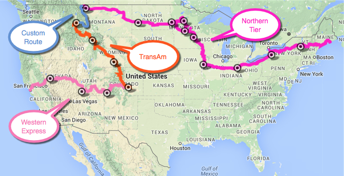
This updated map illustrates our likely route across the US, designed to take us through a number of national parks. Our travels across the country are partially based on three official cycle routes created by Adventure Cycling Association, including the Western Express Route (the pink route) which hooks into the official TransAm route (orange), and the Northern Tier route (fuchsia route).
Our plans are fairly specific for the first bit: Starting at Baker Beach in San Francisco, taking the ferry to Vallejo (yes, odd to take a boat, but this is part of the official San Francisco Western Express route), and heading to Davis, Sacramento, and then points east, beginning with the challenge of climbing the Sierras.
You’ll see that we’re backtracking along the official TransAm route in order to pick up some national parks before heading east again, generally following along the Northern Tier route.
The great thing about these routes is that they keep us on backroads that are more bike friendly (bike lanes and/or less traffic).
We are excited about visiting many parks, including Zion & Bryce, Mesa Verde, Rocky Mountain, Grand Tetons & Yellowstone, and finally Glacier. After that the plans are pretty hazy. But we do expect to end up somewhere between Maine (Acadia?) and Boston, visiting Niagra and upstate NY along the way.
We will post our progress and update the map as we go.

Did you end up doing this route?
LikeLike
Hiya. We evolved the route as we went, but generally followed along. We relied on official bike routes until we crosse the Mississippi and then, as towns became more numerous, we just leveraged Google Maps (in bike setting) to help us figure out where to go. To see where we actually rode, visit this post which summarizes the entire trip and has an overview map: https://itinerantphilosopher.org/2016/10/29/cycling-across-the-us-a-three-minute-video-overview/
LikeLike